Introduction | Tank – Hadley | Tank – Eddies | Atmosphere – Hadley | Atmosphere – Eddies | Theory | For Teachers | Wiki
Eddy Heat Transport
Middle latitude weather systems (see WV satellite loop) are the primary mechanism of poleward heat transport. See an example of observed eddies stirring the N-S temperature gradient – 850 mb Temperature loop.
The meridional heat flux due to transient eddies is defined by
where the overbar is a time-mean over a period of time, here chosen to be a month, and the prime the eddy contribution, the departure from the monthly mean. The rhs terms are:
We can plot these data from analyzed fields as follows.
Plotting the Transient Meridional Heat Flux
Using the NCEP Reanalysis online plotting interface from the CDC (Climate Diagnostic Center), the transient meridional heat flux can be plotted in a number of different ways.
January Transient Meridional Heat Flux
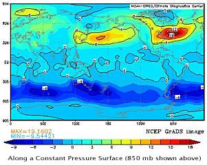
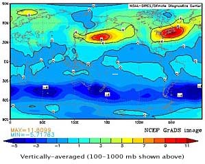
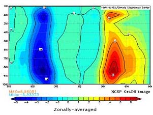
Note that the regions of highest meridional heat transport are located at about 45N and correspond to the middle-latitude storm tracks. The largest transport occurs in the Pacific and Atlantic Oceans, directly downstream of continents. Additionally, there are two local maxima in the vertical profile, one at 850 mb (the top of the atmospheric boundary layer), and another at 200 mb (the region of strongest jet).
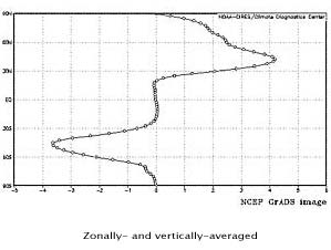
The zonal average of the transient heat flux is calculated using
where x2-x1 = 2pa cosφ, a is the Earth radius, and φ latitude.
The net northward heat flux by transient eddies is given by
where hydrostatic balance has been used to express the rhs as an integral in pressure.
Using this relation, and our NCEP Reanalysis plots, we can compute the net January northward transport of sensible heat by transient eddies across a given latitude. What is the percentage contribution by transient eddies to the total meridional heat transport at 45°N plotted below?