Introduction | Tank – Hadley | Tank – Eddies | Atmosphere – Hadley | Atmosphere – Eddies | Theory | For Teachers | Wiki
1. The Hadley Cell: Overturning Circulation
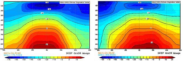
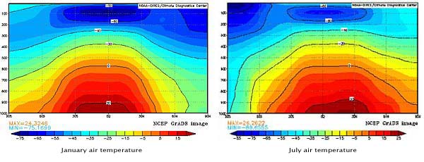
The warmest air, regardless of season, is found near the equator. If earth were not rotating, then warm air would rise in equatorial latitudes, move toward the poles, and colder, denser air would sink and flow equatorwards to replace it. However, because earth rotates, poleward motion aloft is impeded and, in fact, air typically sinks in the subtropics, well before it reaches the pole. The meridional circulation in the tropics, known as the Hadley circulation, is very efficient at carrying heat polewards and smoothes out horizontal temperature gradients, very evident in the temperature plots below.
Plotting the Overturning Hadley Circulation
Using the ESRL- NCEP Reanalysis online plotting interface, we can plot the components of the Hadley circulation – see instructions.
The vertical wind (plotted below, left) in pressure coordinates is given by:
where p is the pressure, D/Dt is the total derivative, ρ is the density, g is the acceleration due to gravity, and w is the vertical velocity in height coordinates, z. Note that the hydrostatic equation has been used in the above and there is a minus sign because p decreases as z increases.
Vertical velocity shows regions of rising and descending air, with negative values of ω, by definition, describing rising air. Also plotted below is the zonally-averaged northward, or meridional, component of velocity. Putting the two plots together shows the overturning circulation of the Hadley cell.
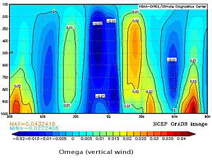
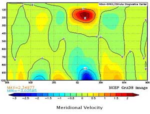
Exercise: Plot the overturning July circulation and compare with January. Plot an annual average of the overturning circulation.
2. The Hadley Cell: Zonal Wind and the Subtropical Jet
Thermal Wind
The thermal wind relationship tells us that there will be a vertical wind shear if there are horizontal temperature gradients: if T only depends on meridional position, y, then:
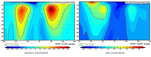
As the upper branch of the Hadley cell moves polewards, the Coriolis force deflects the flow to the east in both hemispheres, creating a zonal jet which, by thermal wind, is associated with a strong meridional temperature gradient.
Zonally-averaged January and July Air Temperature and Zonal Wind
Note that the winter hemisphere has a stronger jet and is associated with a greater horizontal temperature gradient. Note also that the presence of weak easterly trade winds, dragged toward zero by bottom friction.
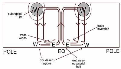
Overturning Circulation + Zonal Wind – The Hadley Cell
A schematic diagram of the annually-averaged Hadley cell is shown below. Upper level, poleward flowing air, is deflected eastward by the Coriolis force to form the westerly subtropical jets in both hemispheres with predominantly eastward flow at the surface (i.e. surface westerlies). Equatorward motion near the surface is deflected westwards (i.e. to form surface easterlies) creating the trade winds. Subsidence in the subtropics creates warm, dry desert regions through adiabatic compression of dry upper tropospheric air. Many of the desert regions around the globe coincide with the sinking branch of the Hadley circulation.
Exercise
Check out the thermal wind balance using the temperature and zonal wind data from the plots above.
3. Zonal Asymmetry – The Walker Circulation
In reality the tropical circulation is not axis-symmetric in large part due to the presence strong land/sea temperature contrasts.
Outgoing Longwave Radiation (OLR)
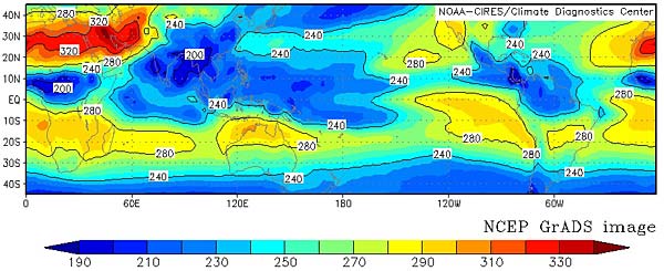
The plot above shows outgoing longwave radiation (OLR) in the tropics averaged over many July’s. Larger (lower) values imply that energy is emanating from lower down (higher up) in the troposphere, i.e. an indicator of clear (cloudy) skies, and subsidence (rising motion). In the western equatorial Pacific, OLR is indeed lower than in the eastern equatorial Pacific, suggestive of a circulation in the zonal direction with rising motion over Indonesia and sinking motion in the eastern Pacific.
The persistent region of lower surface pressure in the western Pacific and higher surface pressure to the east, sets up a circulation pattern known as the Walker circulation, in which air rises in the western equatorial Pacific, moves eastward aloft, and then subsides over the eastern Pacific. The Walker Circulation is shown below.
Walker Circulation (along Equator) in January
